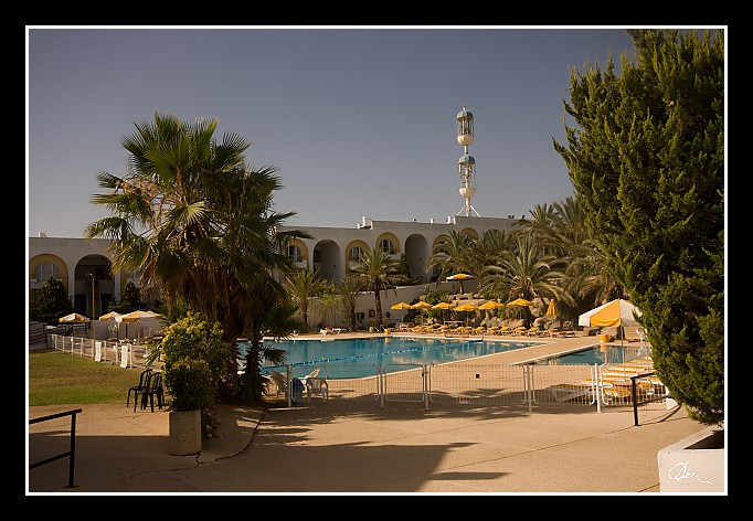
| Tento hotel se nachází ve měste Ariel a zatím se stal terčem dvou sebevražedných teroristických útoků. Jeden z nich popisuji zde: http://www.zingor.cz/img/static/file/051202%20Izrael%20-%20Pribeh%20Tovy.pdf a o tom druhém něco málo napíšu zítra ... |
|
| 3 GPS 29. 06. 2010 08:30:38, Izrael - Ariel, 1/320 sec, f 13, ISO 200 , 20 mm, Blesk No Flash |
Cesta
2010/06 cerven/29 Samari a Shekem-Nablus/20100629-001.jpgContains Exchangeable Image File Format (EXIF) Information
Main Image Information
| Image Width | 682 pixels |
| Image Length | 472 pixels |
| Compression | Uncompressed |
| Photometric Interpretation | RGB (Red Green Blue) |
| Make (Manufacturer) | Canon |
| Model | Canon EOS 40D |
| X Resolution | 1207959552/16777216 (72) pixels per 'Resolution Unit' |
| Y Resolution | 1207959552/16777216 (72) pixels per 'Resolution Unit' |
| Planar Configuration | Chunky Format |
| Resolution Unit | Inches |
| Date and Time | 2010:07:09 12:07:42 (Format: YYYY:MM:DD HH:mm:SS) |
| YCbCr Positioning | Chrominance components Centred in relation to luminance components |
EXIF Image File Directory (IFD) contents
| Exposure Time | 1/320 (0.003125) seconds |
| Aperture F Number | 13/1 (13) |
| Exposure Program | Aperture priority |
| ISO Speed Ratings | 200 |
| Exif Version | 0221 |
| Date and Time of Original | 2010:06:29 08:30:38 |
| Date and Time when Digitized | 2010:06:29 08:30:38 |
| APEX Shutter Speed Value (Tv) | 8321928/1000000 (8.321928) |
| APEX Aperture Value (Av) | 7400879/1000000 (7.400879) |
| APEX Exposure Bias Value (Exposure Compensation) | 0/1 (0) EV |
| Metering Mode | Pattern |
| Flash | Flash did not fire, compulsory flash suppression mode |
| FocalLength | 20/1 (20) mm |
| Sub Second Time of Original | 02 |
| Sub Second Time when Digitized | 02 |
| Focal Plane X Resolution | 3888000/876 (4438.3561643836) pixels per 'Focal Plane Resolution Unit' |
| Focal Plane Y Resolution | 2592000/583 (4445.9691252144) pixels per 'Focal Plane Resolution Unit' |
| Focal Plane Resolution Unit | Inches |
| Special Processing (Custom Rendered) | Normal process |
| Exposure Mode | Auto exposure |
| White Balance | Manual white balance |
| Scene Capture Type | Standard |
| Pixel X Dimension | 682 pixels |
| Pixel Y Dimension | 472 pixels |
| Colour Space | Uncalibrated |
| Components Configuration | Component 1: Y (Luminance) Component 2: Cb (Chroma minus Blue) Component 3: Cr (Chroma minus Red) Component 4: Does not exist |
| User Comment |
GPS Info Image File Directory (IFD) contents
| Longitude | 35/1 (35), 976447/100000 (9.76447), 0/0 (Degrees Minutes Seconds East or West) |
| East or West Longitude | E |
| Latitude | 32/1 (32), 645367/100000 (6.45367), 0/0 (Degrees Minutes Seconds North or South) |
| North or South Latitude | N |
| Altitude | 515400/1000 (515.4) Metres with respect to Altitude Reference |
| Altitude Reference | Sea Level |
Contains Extensible Metadata Platform (XMP) / Resource Description Framework (RDF) Information
Dublin Core Metadata Initiative RDF Segment
| Creator(s) (Authors): | Ordered List: Ing. Daniel Žingor |
| Rights Statement: | List of Alternates: © Daniel Žingor |
| Subject and Keywords: | Unordered List: Architektura Reportáž Web |
| Description (Caption): | List of Alternates: Tento hotel se nachází ve měste Ariel a zatím se stal terčem dvou sebevražedných teroristických útoků. Jeden z nich popisuji zde: http://www.zingor.cz/img/static/file/051202%20Izrael%20-%20Pribeh%20Tovy.pdf a o tom druhém něco málo napíšu zítra ... |
XMP - embedded TIFF Segment
| Make: | Canon |
| Model: | Canon EOS 40D |
| Image Width: | 3888 |
| Image Length: | 2592 |
| Samples Per Pixel: | 3 |
| Bits Per Sample: | Ordered List: 16 16 16 |
| Photometric Interpretation: | 2 |
XMP - embedded EXIF Segment
| Exif Version: | 0221 |
| Exposure Time: | 1/320 |
| Shutter Speed Value: | 8321928/1000000 |
| F Number: | 13/1 |
| Aperture Value: | 7400879/1000000 |
| Exposure Program: | 3 |
| Date & Time of Original: | 2010-06-29T08:30:38.02+02:00 |
| Date & Time Digitized: | 2010-06-29T08:30:38.02+02:00 |
| Exposure Bias Value: | 0/1 |
| Metering Mode: | 5 |
| Focal Length: | 20/1 |
| Custom Rendered: | 0 |
| Exposure Mode: | 0 |
| White Balance: | 1 |
| Scene Capture Type: | 0 |
| Focal Plane X Resolution: | 3888000/876 |
| Focal Plane Y Resolution: | 2592000/583 |
| Focal Plane Resolution Unit: | 2 |
| ISO Speed Ratings: | Ordered List: 200 |
| Flash: | Fired = False Return = 0 Mode = 2 Function = False Red Eye Mode = False |
| Pixel X Dimension: | 3888 |
| Pixel Y Dimension: | 2592 |
| GPS Longitude: | 35,9.764470E |
| GPS Latitude: | 32,6.453670N |
| GPS Altitude: | 515400/1000 |
| GPS Altitude Reference: | 0 |
XMP Basic Segment
| Resource Last Modify Date: | 2010-06-29T18:16:10+02:00 |
| Original Creation Date: | 2010-06-29T08:30:38.02+02:00 |
| Unknown field xap:Rating: | 3 |
| Unknown field xap:Label: | Green |
Unknown RDF Segment 'aux'
| Unknown field aux:Lens: | 10.00 - 20.00 mm |
| Unknown field aux:Firmware: | Firmware Version 1.0.3 |
Photoshop RDF Segment
| Unknown field photoshop:LegacyIPTCDigest: | EA20940AFBF52D322CB867DF2CB70E1C |
Unknown RDF Segment 'znr'
| Unknown field znr:RawDevelopSettings: | UEsDBBQAAAAIAAOS3TxOmBL1zwIAAGcJAAAMAAAAc2V0dGluZ3MueG1sbZZLbtswEIb3BXqHHqBO ZDtx4CAgELT7Au02G4YaW0QkUhhSTu2b9BA9QRddFD1Pr1BKGj4VrzTf/DMUh8OR//36/XDB1/sa TtDqnr1/N5mPLQKvz49930qo2frh+g1KWoOi57Zhn++fav0ydKDs+enLM/LLy/lpU62rVbVbbfYf vvGO//3x5+fEqt1mv6qq9dWnr5s5uU9DWTlaeeDCHmRrARmJCkraVh4ba1g1a8jyb9fwWr8GpzfJ K7SyyI317mB7f8tR2nNwk0leC10PyO2AwHZ329tZlFKfhncp9dly6pNKZdnqjnKNRpJkNJPoxGvG JNxKrZirLm02MlKdpDsXJSBqAiFFM4T3Gx+Jvj576J6IHTR23LLtzMkiXw2dNlwKHxXsUPdWo+m5 iMWIxOeXLbiOpN4ji3yD6YxFUEfXMDvKkLIoQ17LwbD11SbKiEWRbRBMo9va91nGoq4dOq3as3+n hJAGvvdCdz2rrnx9PSGBQhfh9zwbweNKED2jEVsYewUmbWICvtyiZ1RoEZZyjazMeCw+LAJSoLbc wvSyJCHiTwl1jyDsrHC/j+FhXT7QKfqI0AfGTrfatwGZsYUE1Ip3wEIXeZDdbevP4ia75LY4Irrd C3XJs9zPLajayAuwuyx55Hn2pX7hKPIPWEu3pXFibYslEle5yhtRb/mytdxAAGXGEXVzmy4Ueb7K Ur9wZPnhxDbZgQec513oIvfdqRWIAU/+5KOdjYhGHixLJ8QESHJEfkb3IfLl8XbiPiKAYrf7KJhJ InHVdPNwHRUTCAI99O4OazOO6CBKYap00zHVxGE5mdMOMsFMFpp5l1UpLDbvcJwEadbFfJhorHCq XdR9okpLA66Ug5i/KElA4cpWCAMmW6EcO7QhdQI0ZfYEZ2rX7Mh71ONnIA/IPGlMU2P+x6Cghbb4 o1DiVD02iRG8hUwcqdNe53+q/gNQSwECAAAUAAAACAADkt08TpgS9c8CAABnCQAADAAAAAAAAAAB ACAAAAAAAAAAc2V0dGluZ3MueG1sUEsFBgAAAAABAAEAOgAAAPkCAAAAAA== |
Unknown RDF Segment 'Iptc4xmpCore'
| Unknown field Iptc4xmpCore:Location: | Izrael - Ariel |
